Showing posts with label ferry. Show all posts

Tuesday, 24 July 2012

Mille Bornes - The Olympic Peninsula Ride Part 2

View from Port Townsend Ferry
The Coupeville - Port Townsend ferry is a nice ferry - not too small, not too long, not too expensive - in fact it was only $5.50 for me and my scoot. On board there were plenty of maps and brochures, comfortable seating, and a small cafeteria, although it was closed by the time I got there. I wandered around the boat, checking out all of the different levels and went outside a few times. The crossing was a bit more than half an hour and the weather was nice as we made our way into Port Townsend.

The Great Big Sea

After I arrived in Port Townsend, I drove around the main area by the water, looking for a place to eat. I was impressed by the town - it has a nice feel to it - a bit touristy but still friendly - and is very pleasing to the eye.

Water Street, Port Townsend
After parking (in a motorcycle specific spot, no less) I wandered around, looking for a place for lunch. I ended up stopping at the Water Street Creêerie, hoping to find a nice savoury crepe. I was not disappointed. I ordered the California crêpe which had turkey, cheese, avocado and lots of vegetables. After the friendly waiter delivered my meal, I sat outside, in the sun, and marvelled at the finished product. It was a massive thing, and I was a bit intimidated by its size but managed to finish it all off!

A tasty California  crêpe - but very big!
Left Port Townsend - 1pm 195 km

Troll Haven Castle
After my meal, I gassed up and headed out along the northern part of the Olympic Peninsula. After the last bit of SR20, I hit highway 101 which was nice to ride as it went by both trees and sea. My first stop was Troll Haven in Gardiner, A little off the road, it is a group of rental homes but the one that is interesting is the castle at the entrance.


Next stop was my first - and as it turned out, my last - casino. For quite a while, I used to stop at every casino I was, dropped $5 in a slot machine, and stay until I either doubled my money or lost the $5. I thought I would reinstate the practice but it didn't turn out that well. For starters, I didn't have a $5 so I ended up putting $10 in the machine. I got ahead about $2 at the beginning and then started the slow spiral down to nothingness.

Fancy scooter in the casino
It was a lot like being in Vegas because you could smoke in the casino. I was also offered a drink by a cute waitress but declined as I still had a long ride ahead. On the way out, I noticed the non-smoking slots of which there were four or five huddled around the entrance in the lobby. Also on the way out I saw this beautiful motorcycle (not sure about the details, just know it looks nice) and then headed out on highway 101.

They were both nice stops to make and I would have made more similar stops if I didn't have such a large amount of distance to cover. It had taken me almost 5 hours to go 195 km. Little did I realize that I when I left Port Townsend, that I had about 250 km still to go!


I was able to get some pictures near the water as I continued on. The weather, unfortunately turned form sunny and warm to misty and cool. The top half of the peninsula was fairly good, weather wise, but things started to decline as soon as I headed south. By the time I got to Forks, with its turn off for Rialto Beach, I was in no mood to take a half an hour side trip. Bah, I told myself, I've seen enough virgin beaches to last me a lifetime! Bah!


Forks - 4:15pm   - 365 km


The last two hours were moist and cool. Luckily, I had brought a long sleeved shirt as it was cooler than I thought it would be. It wasn't exactly raining but you could feel water permeate everything. I even zipped up my side zippers on my Corazzo jacket.


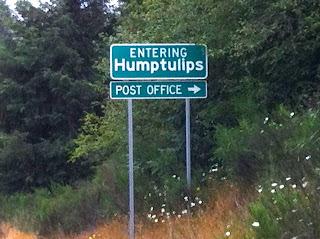
A little comic relief was offered as I passed the teeny place called Humptulips.  According to Wikipedia:
The name Humptulips may have come from a local Native American language, meaning 'hard to pole', referring to the difficulty local Native Americans had poling their canoes along the Humptulips River.According to other sources the word means 'chilly region' Another possibility is that Humptulips was the name of a band of the Chehalis tribe.


I finally made it into Aberdeen at 6:15pm. I hate to be negative but the fact that Kurt Cobain was born here and started 'grunge music' became very clear as the town seemed rather, well, grungy. Maybe that's just because my hotel was cheap and I only saw along the highway. I hope so.


I checked into the Olympic Hotel ($60) and, after a nice hot shower, went to Safeway and picked up some Chinese food and a bottle of wine. I stuffed myself on the tasty food ($4.99 for two types of dished, rice and an egg roll that tasted like fish) and had two glasses of wine before I staggered to bed (from exhaustion, mind you, not the two glasses of wine).

I made it!

Aberdeen    6:15pm (10 hours riding)   537 km

Thursday, 20 August 2009

Sunshine Coast and Island Scooter Ride (Part 1)

Finally, a scooter trip!

The plan was to go to Horseshoe Bay, and up the Sunshine Coast to stay in Powell River for a night. The next day I planned to go to Comox on Vancouver Island and then to either Nanaimo or Victoria to take a ferry back to the mainland.

Because of the length of each entry (and all the pretty pictures) I've split up the trip into three parts. Here's part 1.

Maple Ridge - Horseshoe Bay
Distance: 77km
Time: 2 hours


Although I have made through a number of renos this summer relatively unscathed, I've managed to injure myself while holidaying - my knee when attempting a cannonball in 4 and a half feet of water ("Don't jump, Dad, don't jump!") and slicing off the top half of my nail and a bit of nail bed with a utility knife while attempting to jury rig a pannier to my scooter. Despite these minor injuries, I headed off today for my circle tour of the coast and island.

The first leg on my route was to go to Vancouver and continue on to Horseshoe Bay where I would catch the ferry for the Sunshine Coast - Langdale. I wanted to get to get the 9:40 ferry so I left around 7 AM thinking that I would have lots of time.

The ride to Vancouver was uneventful except for the numerous construction projects on the way. I figured I was OK as I crossed the Lions Gate Bridge at 8:40.

I love going over the bridge - it's so high up and the view from the scooter is truly spectacular.

I had decided to take Marine Drive all the way to Horseshoe Bay to avoid going on the freeway. As the name suggests, the route goes along the water, snaking around houses, stone fences, trees, and shoreline. It was a very scenic ride but it took a bit longer than I thought, so there was no time for photos.

I arrived in the village of Horseshoe Bay at 9:15 but I couldn't get to the ferries - I was supposed to double back on the freeway four kilometres and then turn around. I really didn't want to go on the freeway and it's also all uphill out of Horseshoe Bay so I started on the freeway but luckily spied a place where the cement barriers separating the freeway lanes had a break. I hopped this break and then a curb and found myself zooming towards the ferries - but without a ticket!


I flagged down a ferry flag person and he radioed his boss:

Flagperson: I've got a scooter here who needs a ticket but doesn't want to go on the freeway.
Boss: How'd he get there?
Flagperson: He hopped the curbs down by the chute.
Boss: He can hop a curb but he can't go on the freeway?

I then went down to the terminal and bought a ticket there. But then I had to do the exact same thing and hop the barrier again to get back in the line up!


By this time it was 9:30 and I lined up with the other motorcyclists until the ferry left a few minutes later.


Langdale - Earl's Cove
Distance: 88 km
Time: 2 hours


From Langdale, I took the Sunshine Coast Highway 101 north.


It's a fairly nice highway but would have been better if it spent more time right near the water. It's also only two lanes so I had to pull off fairly often, particularly until I figured out to let all the ferry traffic leave first.


At Red Roofs, about half way, I stopped in to visit my nephew and nieces. My niece, Charlotte, had her birthday the following day so I wanted to surprise her with my visit and a little something. I also had a quick lunch and a wonderful view of the ocean.


My sister-in-law takes her kids there every summer to their family cabin and they spend most of the summer holidays up there. Nice!

After lunch I sped north to Earl's Cove, about another hour, on the highway. It was better as there was little traffic. I fuelled up about 20 km from the ferry, not wanting a repeat of the White Rock fiasco!


I got to the terminal in good time and had a chance to sit in the sun before I made the 50 minute voyage to Saltery Bay.


Saltery Bay - Powell River
Distance 50 km
Time: 40 minutes


Upon arriving at Saltery Bay, I headed off, jacketless, pulling off the road until the ferry traffic passed.


After that, it was a delgihtful ride on the 101. I stopped a few times for photos as the weather was fine and I wasn't on a strict schedule. It was a lot less stressful as, when there were cars behind me, the breakdown lane was a good width.


It wasn't far and I was in Powell River.

More about Powell River next blog entry.